The 2024 Atlantic hurricane season caused hundreds of deaths, and more than $200 billion in damages. In efforts to protect lives and property, the The Texas Advanced Computing Center supercomputers, namely Frontera, Stampede3, and Lonestar6, were deployed to feed storm models and events into the CERA platform for state-of-the-art surge forecasting and emergency preparedness. TACC is exploring artificial intelligence and machine-learning techniques to even further accelerate predictions and refine simulation models.
Thank you to the State of Louisiana and the LSU Center for Computation & Technology for making significant contributions to support storm surge modelling and real-time operations. We are proud to be named as one of LSU’s most in-demand tools to protect coastal communities from flooding. 🌀
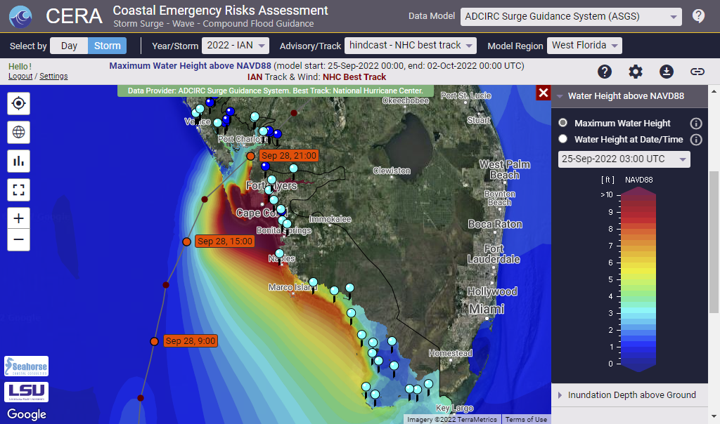
Hurricane IAN was a destructive category 4 hurricane that caused severe damage across the states of Florida and South Carolina.
The CERA Group delivered ongoing forecast results to 90,000 users over the entire course of the storm. The ADCIRC Surge Guidance System Team, the LSU Center for Computation and Technology (CCT) and High Performance Centers in TX and LA were key partners for our success to provide uninterrupted storm surge modeling and visualization guidance.
The Texas Advanced Computing Center published a Q&A, covering the role of the Coastal Emergency Risks Assessment (CERA) Storm Surge and Flood Web Mapping Visualization Tool and its importance during hurricane IAN.
Maximum storm surge and inland flooding as displayed on the Coastal Emergency Risks Assessment (CERA) website for hurricane IAN (Sep/Oct 2022). Data source: ADCIRC Surge Guidance System (ASGS).
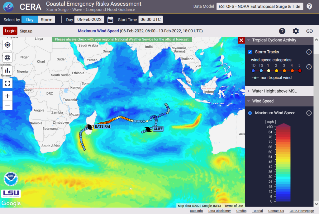
Did you know that about 85 tropical storms form annually over the warm tropical oceans of the globe? And while the majority of tropical cyclones happen in the northern hemisphere with most activity occurring between mid-August and mid-October, tropical cyclones in the southern hemisphere are most frequent during the December through April warm season.
The Coastal Emergency Risks Assessment (CERA) web storm surge guidance system provides water levels and wind information from NOAA’s Global Extratropical Surge and Tide Operational Forecast System (G-ESTOFS) for storm surge and wind guidance around the year. One of our latest features is the overlay of global hurricane and typhoon track information coming from the National Hurricane Center (NHC) and the Joint Typhoon Warning Center (JTWC).
CERA displaying tropical cyclone track activity in the southern hemisphere in Feb 2022
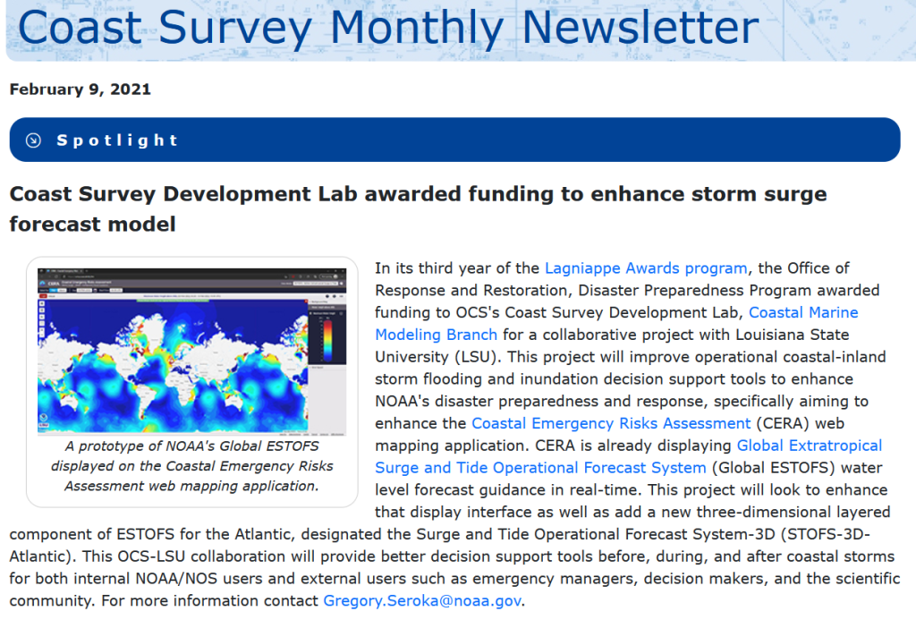
In January 2022, the NOAA Coast Survey Development Lab (CSDL) was awarded funding to improve storm surge modeling to further enhance NOAA’s disaster preparedness and response. The Louisiana State University (LSU) Coastal Emergency Risks Assessment (CERA) web mapping application is an integral part of this collaborative project to deliver storm surge and inland flooding model results to the public and the modeling community.
The award was published in the February edition of NOAA’s Coast Survey Newsletter:
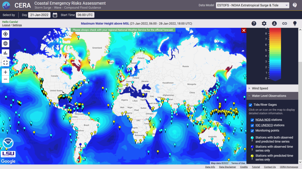
We are delighted to introduce our latest CERA enhancement that provides 558 global water level points from the NOAA Extratropical Surge and Tide Operational Forecast System (ESTOFS) system on a daily basis.
About ESTOFS: The NOAA/NOS/Coast Survey Development Lab and the NOAA National Centers for Environmental Prediction (NCEP) produce storm surge guidance for extratropical systems through their Extratropical Surge and Tide Operational Forecast System (ESTOFS) four times daily out to 7.5 days. The ESTOFS model uses the storm surge model ADCIRC forced by real time output of atmospheric pressure, winds, and sea ice from the NCEP Global Forecast System (GFS) and is run on NOAA’s WCOSS super computing system to produce numerical outputs. The global unstructured grid consists of 8 million nodes with a coastal grid resolution of up to 80 m for Hawaii and the US West Coast, and up to 120 m for the US East Coast, Puerto Rico, Micronesia, and Alaska.
The Coastal Emergency Risks Assessment (CERA) visualization tool provides ESTOFS results on its interactive visualization website (https://cera.coastalrisk.live) once daily, including global water level heights and wind speed results. The newly added ESTOFS water level stations combine predicted forecast water levels from the model with observed water levels from the NOAA Tide & Currents service and the Intergovernmental Oceanographic Commission (IOC) Sea Level Station Monitoring Facility.
In addition to this new feature, we made major updates to all water level stations along the US coast, including services from NOAA, USGS, and the USACE.
CERA-PRO provides global water level stations from the NOAA Extratropical Storm Surge and Tide Operational ForecastSystem (ESTOFS) once daily
On July 27, 2021, the National Centers for Environmental Prediction (NCEP) Central Operations upgraded the Global Extratropical Surge & Tide Operational Forecast System (Global ESTOFS) to version 2. This upgrade contains major improvements in model performance, resolution, and coverage to provide high resolution water level forecast guidance including storm tide for the entire globe.
The CERA visualization system makes this upgrade available through it’s online portal at cera.coastalrisk.live.
FEMA’s Hazus Program provides standardized tools and data for estimating risk from earthquakes, floods, tsunamis, and hurricanes.
We have recently learned that the FEMA Hazus Development Group uses our CERA storm surge guidance visualization system to validate the development of a data tool for integrating hazard data into the FEMA Hazus application.
Thank you FEMA for the trust in the quality of the provided data through the CERA site at https://cera.coastalrisk.live
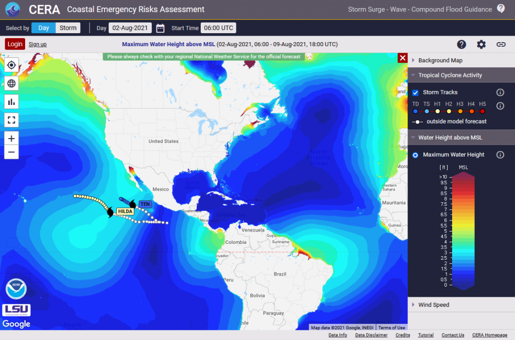
The fifth named storm of the 2021 Atlantic hurricane season formed over the Atlantic early Thursday (July 1).
According to the National Hurricane Center, Tropical Storm Elsa tracks westward at a quick pace of 25 mph.
Together with our partners at Seahorse Coastal Consulting , LSU High Performance Center, and the Texas Advanced Computing Center , the CERA Group has started storm surge guidance using the storm surge model ADCIRC.
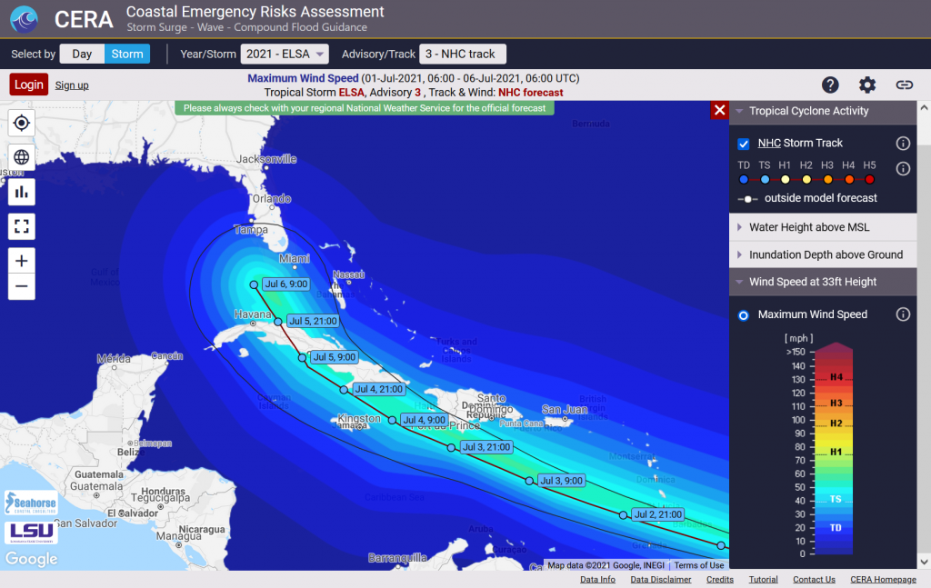
Tropical Storm Claudette (17 June – 21 June , 2021) was already the third named storm of the 2021 Atlantic hurricane season but the first tropical system that targeted both the Gulf and the Atlantic coasts.
We used high resolution storm surge model meshes for the States of Louisiana and North Carolina and a vortex wind model to represent the NHC consensus track wind fields and the associated predicted storm surge through the ADCIRC Surge Guidance System.
The Compound Flood Inundation Guidance System delivered flood guidance showing compound threat predictions from surge and rainfall for watersheds in Louisiana once daily from June 16 through June 19 and an after-storm guidance on June 21.


 Gage stations for the