Thank you to the WAFB9 team, the CERA team , and all CERA collaborators for this incredible opportunity.
Dr. Noujoud Nader, AI specialist at the LSU Center for Computation & Technology sat down with WAFB9 to talk about the use of AI technologies in the context of LSU’s CERA hurricane storm surge forecasting visualization framework
This coverage highlights the importance of our long-standing work on providing forecasting and visualization services to the communities nation-wide.
Recorded video of WAFB9’s broadcast featuring CERA.
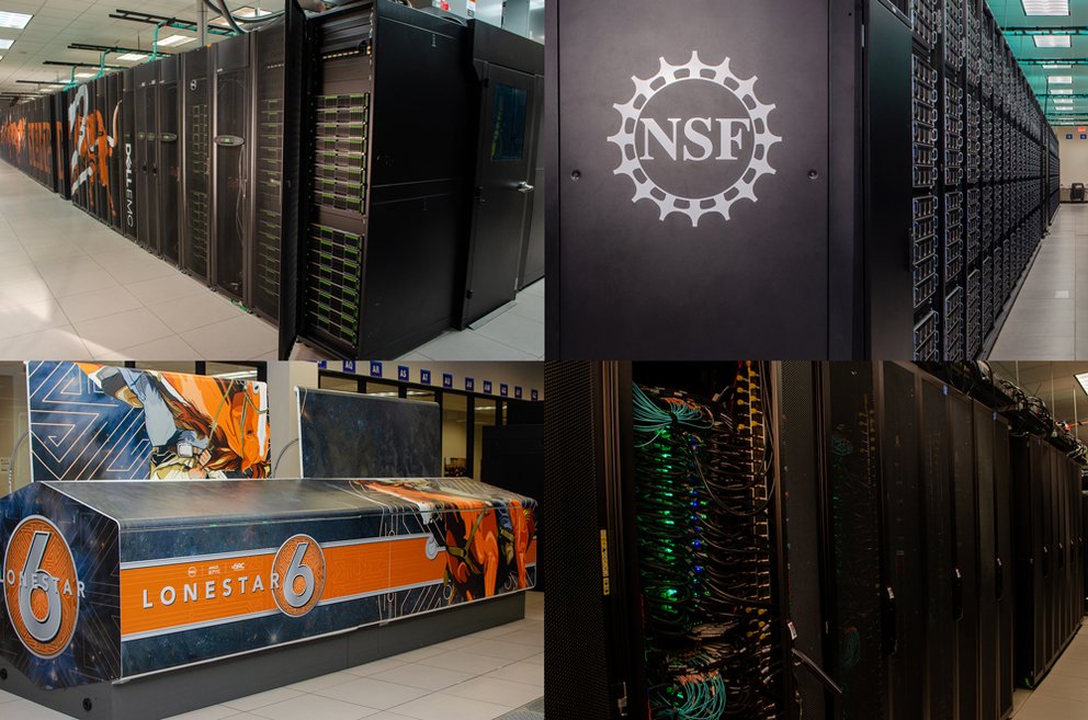
The 2024 Atlantic hurricane season caused hundreds of deaths, and more than $200 billion in damages. In efforts to protect lives and property, the The Texas Advanced Computing Center supercomputers, namely Frontera, Stampede3, and Lonestar6, were deployed to feed storm models and events into the CERA platform for state-of-the-art surge forecasting and emergency preparedness. TACC is exploring artificial intelligence and machine-learning techniques to even further accelerate predictions and refine simulation models.
Thank you to the State of Louisiana and the LSU Center for Computation & Technology for making significant contributions to support storm surge modelling and real-time operations. We are proud to be named as one of LSU’s most in-demand tools to protect coastal communities from flooding. 🌀
Since 2000, a significant amount of tropical storms have made landfall on the Atlantic Coast and the Northern Gulf of Mexico.
Our newly launched website historicalstorms.coastalrisk.live includes more than 50 tropical storms that involved injury or loss of life, incurred damages to property, and made significant economic impact.
The comprehensive CERA Storm Surge Archive archive provides water height, wind, and wave data based on the ‘Best Tracks’ from the National Hurricane Center (NHC) and the ADCIRC storm surge model. Each storm can be explored in detail with CERA’s visualization tool using the Best Tracks – Historical U.S. Storms data model option.
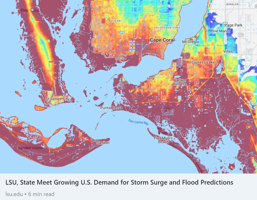
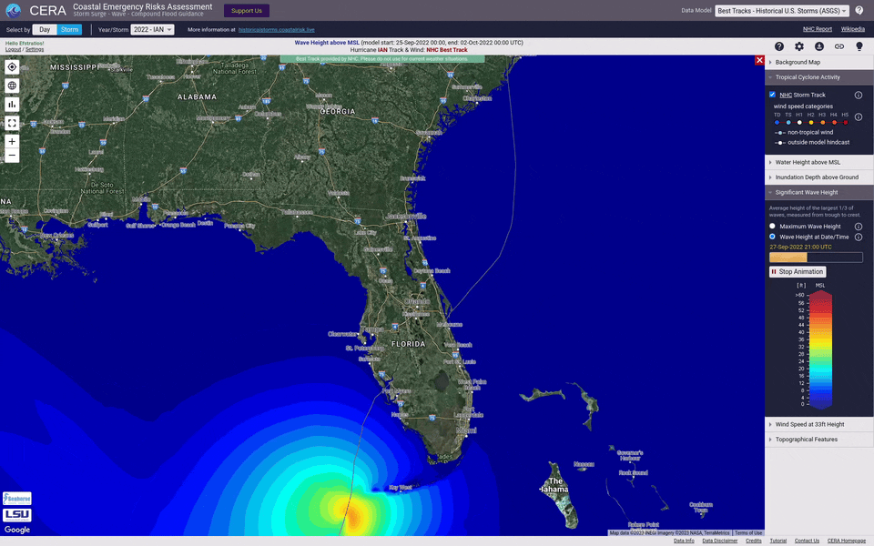
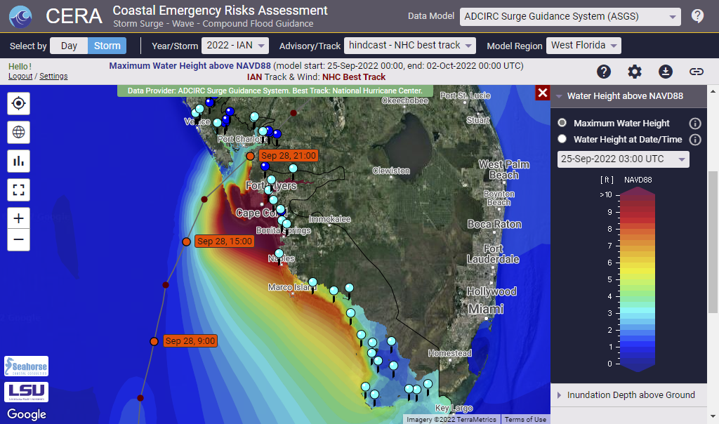
Hurricane IAN impacting West Florida and the Atlantic Coast in October 2022
Hurricane IAN was a destructive category 4 hurricane that caused severe damage across the states of Florida and South Carolina.
The CERA Group delivered ongoing forecast results to 90,000 users over the entire course of the storm. The ADCIRC Surge Guidance System Team, the LSU Center for Computation and Technology (CCT) and High Performance Centers in TX and LA were key partners for our success to provide uninterrupted storm surge modeling and visualization guidance.
The Texas Advanced Computing Center published a Q&A, covering the role of the Coastal Emergency Risks Assessment (CERA) Storm Surge and Flood Web Mapping Visualization Tool and its importance during hurricane IAN.
Maximum storm surge and inland flooding as displayed on the Coastal Emergency Risks Assessment (CERA) website for hurricane IAN (Sep/Oct 2022). Data source: ADCIRC Surge Guidance System (ASGS).
Did you know that about 85 tropical storms form annually over the warm tropical oceans of the globe? And while the majority of tropical cyclones happen in the northern hemisphere with most activity occurring between mid-August and mid-October, tropical cyclones in the southern hemisphere are most frequent during the December through April warm season.
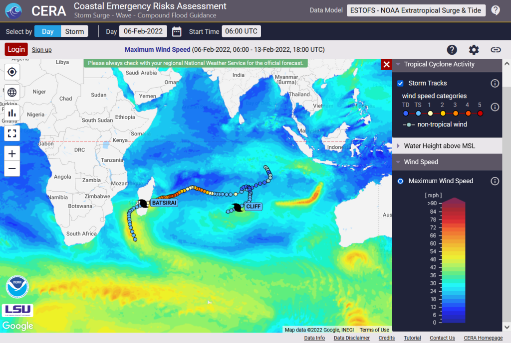
The Coastal Emergency Risks Assessment (CERA) web storm surge guidance system provides water levels and wind information from NOAA’s Global Extratropical Surge and Tide Operational Forecast System (G-ESTOFS) for storm surge and wind guidance around the year. One of our latest features is the overlay of global hurricane and typhoon track information coming from the National Hurricane Center (NHC) and the Joint Typhoon Warning Center (JTWC).
CERA displaying tropical cyclone track activity in the southern hemisphere in Feb 2022
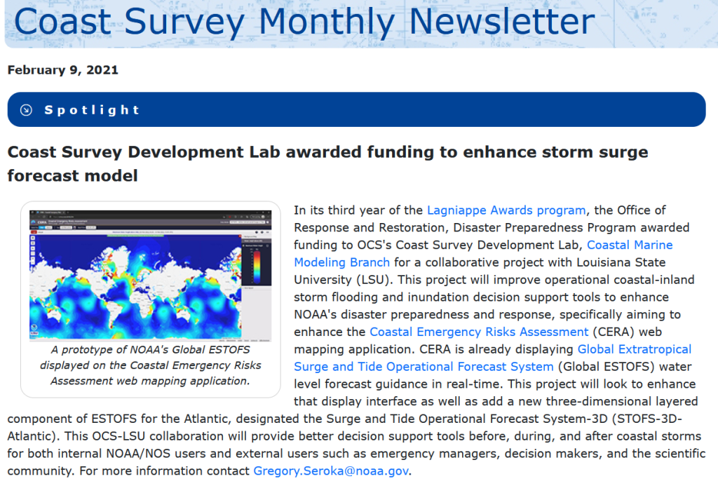
In January 2022, the NOAA Coast Survey Development Lab (CSDL) was awarded funding to improve storm surge modeling to further enhance NOAA’s disaster preparedness and response. The Louisiana State University (LSU) Coastal Emergency Risks Assessment (CERA) web mapping application is an integral part of this collaborative project to deliver storm surge and inland flooding model results to the public and the modeling community.
The award was published in the February edition of NOAA’s Coast Survey Newsletter:
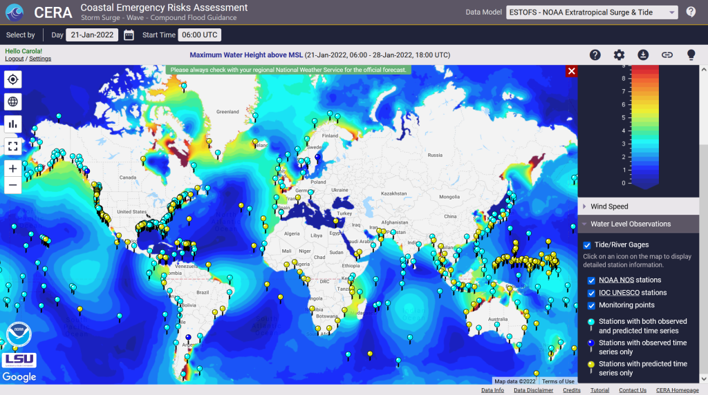
We are delighted to introduce our latest CERA enhancement that provides 558 global water level points from the NOAA Extratropical Surge and Tide Operational Forecast System (ESTOFS) system on a daily basis.
About ESTOFS: The NOAA/NOS/Coast Survey Development Lab and the NOAA National Centers for Environmental Prediction (NCEP) produce storm surge guidance for extratropical systems through their Extratropical Surge and Tide Operational Forecast System (ESTOFS) four times daily out to 7.5 days. The ESTOFS model uses the storm surge model ADCIRC forced by real time output of atmospheric pressure, winds, and sea ice from the NCEP Global Forecast System (GFS) and is run on NOAA’s WCOSS super computing system to produce numerical outputs. The global unstructured grid consists of 8 million nodes with a coastal grid resolution of up to 80 m for Hawaii and the US West Coast, and up to 120 m for the US East Coast, Puerto Rico, Micronesia, and Alaska.
The Coastal Emergency Risks Assessment (CERA) visualization tool provides ESTOFS results on its interactive visualization website (https://cera.coastalrisk.live) once daily, including global water level heights and wind speed results. The newly added ESTOFS water level stations combine predicted forecast water levels from the model with observed water levels from the NOAA Tide & Currents service and the Intergovernmental Oceanographic Commission (IOC) Sea Level Station Monitoring Facility.
In addition to this new feature, we made major updates to all water level stations along the US coast, including services from NOAA, USGS, and the USACE.
CERA-PRO provides global water level stations from the NOAA Extratropical Storm Surge and Tide Operational ForecastSystem (ESTOFS) once daily
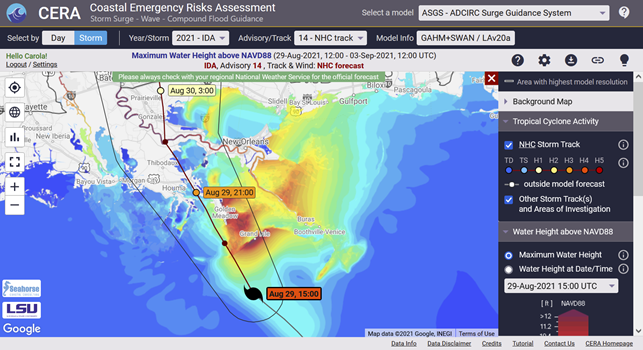
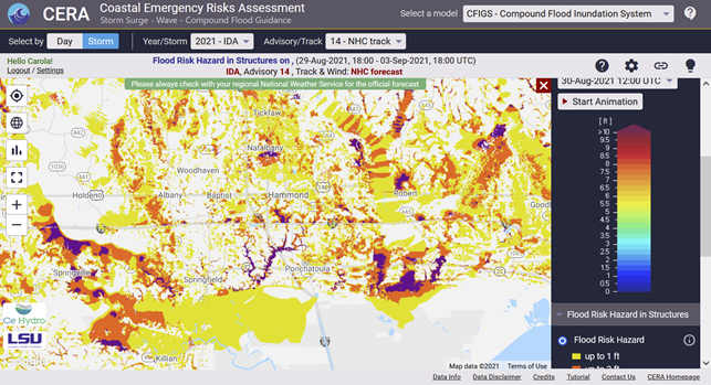
Ida (August 26 – 31, 2021) made landfall as a strong category 4 hurricane near Port Fourchon, LA on August 29. The impacts of Ida are far-reaching across Southeastern Louisiana and beyond. Over a million customers in the region were without power, and for some, restoration is estimated to take weeks or longer. The greater New Orleans area was left completely in the dark, leaving officials scrambling to determine the best path to bring the city and surrounding areas back up. The devastation caused in the coastal areas like Grand Isle, where 100% of structures are reported to have sustained damage, will take years to rebuild. Intense flooding in the River Parishes left homes and businesses destroyed.
CERA delivered visualizations for storm surge model runs from the ADCIRC Surge Guidance System (ASGS) for the NHC official forecast, veer left and veer right scenarios and an increase in overland speed from advisory #6 through #18.
CERA maps from the Compound Flood Inundation Guidance System (CFIGS) were delivered for special advisories. This was the first time that CFIGS went operational for a storm event to provide results in real-time.
CERA got more than 20,000 page views from the public website and 9,000 page views from users with a login during the storm. 350 subscribed users were active on the site during the storm.
CERA/ASGS/CFIGS results were used by the Coastal Protection and Restoration Authority (CPRA) to brief the Louisiana Governor.
CERA received numerous new login requests from high-ranking agencies and organizations, including the Louisiana Governor’s Office of Homeland Security and Emergency Preparedness (GOHSEP).
CERA provided GeoTiff imagery for the inundation impacts that were used by the DHS HAZUS Group for damage assessment, among others.
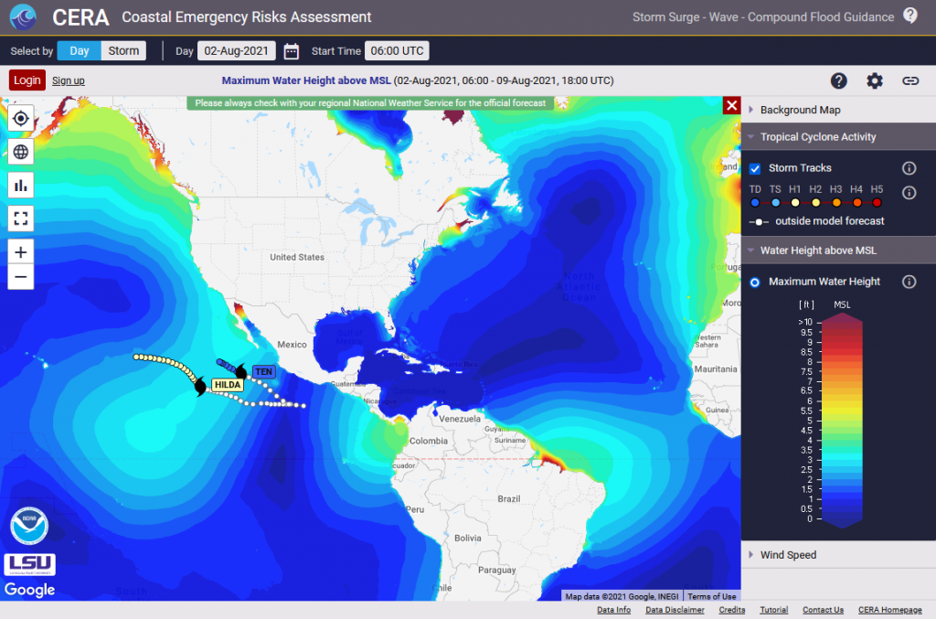
CERA: ADCIRC Surge Guidance System – predicted water levels for Ida, advisory 14 on Aug 29CERA – CFIGS showing the Flood Risk Hazard in Structures layer for IDA, advisory 14 on Aug 29
On July 27, 2021, the National Centers for Environmental Prediction (NCEP) Central Operations upgraded the Global Extratropical Surge & Tide Operational Forecast System (Global ESTOFS) to version 2. This upgrade contains major improvements in model performance, resolution, and coverage to provide high resolution water level forecast guidance including storm tide for the entire globe.
The CERA visualization system makes this upgrade available through it’s online portal at cera.coastalrisk.live.