FEMA’s Hazus Program provides standardized tools and data for estimating risk from earthquakes, floods, tsunamis, and hurricanes.
We have recently learned that the FEMA Hazus Development Group uses our CERA storm surge guidance visualization system to validate the development of a data tool for integrating hazard data into the FEMA Hazus application.
Thank you FEMA for the trust in the quality of the provided data through the CERA site at https://cera.coastalrisk.live
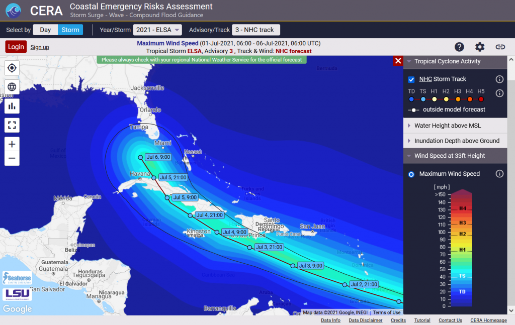
The fifth named storm of the 2021 Atlantic hurricane season formed over the Atlantic early Thursday (July 1).
According to the National Hurricane Center, Tropical Storm Elsa tracks westward at a quick pace of 25 mph.
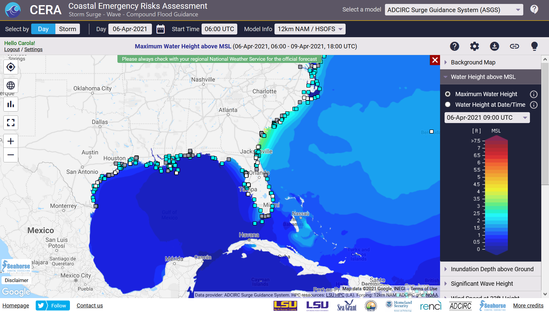
Together with our partners at Seahorse Coastal Consulting , LSU High Performance Center, and the Texas Advanced Computing Center , the CERA Group has started storm surge guidance using the storm surge model ADCIRC.
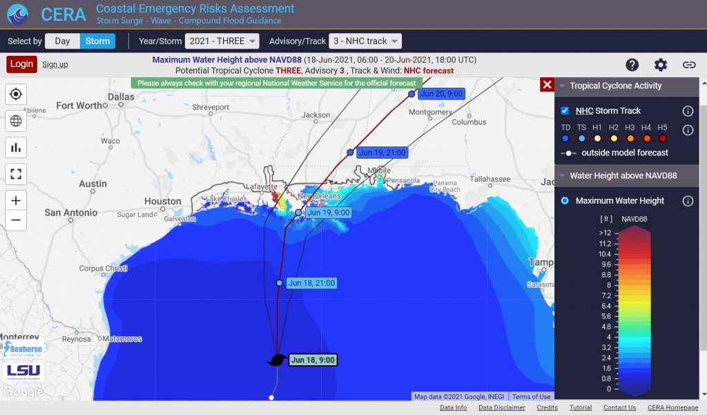
Tropical Storm Claudette (17 June – 21 June , 2021) was already the third named storm of the 2021 Atlantic hurricane season but the first tropical system that targeted both the Gulf and the Atlantic coasts.
We used high resolution storm surge model meshes for the States of Louisiana and North Carolina and a vortex wind model to represent the NHC consensus track wind fields and the associated predicted storm surge through the ADCIRC Surge Guidance System.
The Compound Flood Inundation Guidance System delivered flood guidance showing compound threat predictions from surge and rainfall for watersheds in Louisiana once daily from June 16 through June 19 and an after-storm guidance on June 21.
Potential Tropical Cyclone Three has formed in the Northern Gulf and might strengthen into a tropical system before making landfall along the southern Louisiana coastline. After two short-lived tropical systems in the Atlantic, this would already be the third named storm of the season 2021 – Claudette.
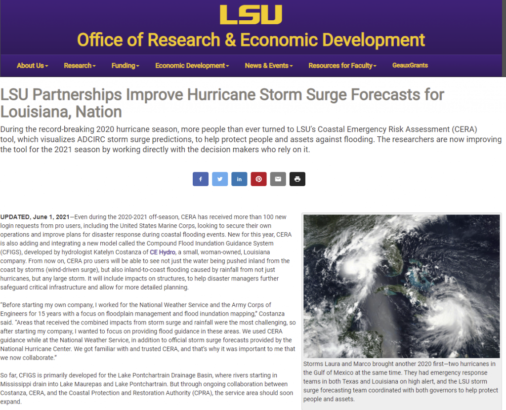
The LSU Office of Research and Development (ORED) recently published an online article about the partnership between LSU and CERA, which can be found here:
The LSU Coastal Emergency Risks Assessment (CERA) visualization tool was recently listed by The Coastal Protection and Restoration Authority as one of their frequently used sites in a CPRA Board Meeting presentation.
CPRA LA uses CERA as an emergency assessment tool to view the impacts of modeled storm surge for hurricanes and tropical events delivered by the ADCIRC Surge Guidance System (ASGS). The ASGS was developed by Seahorse Coastal Consulting, a long-term partner of CERA.
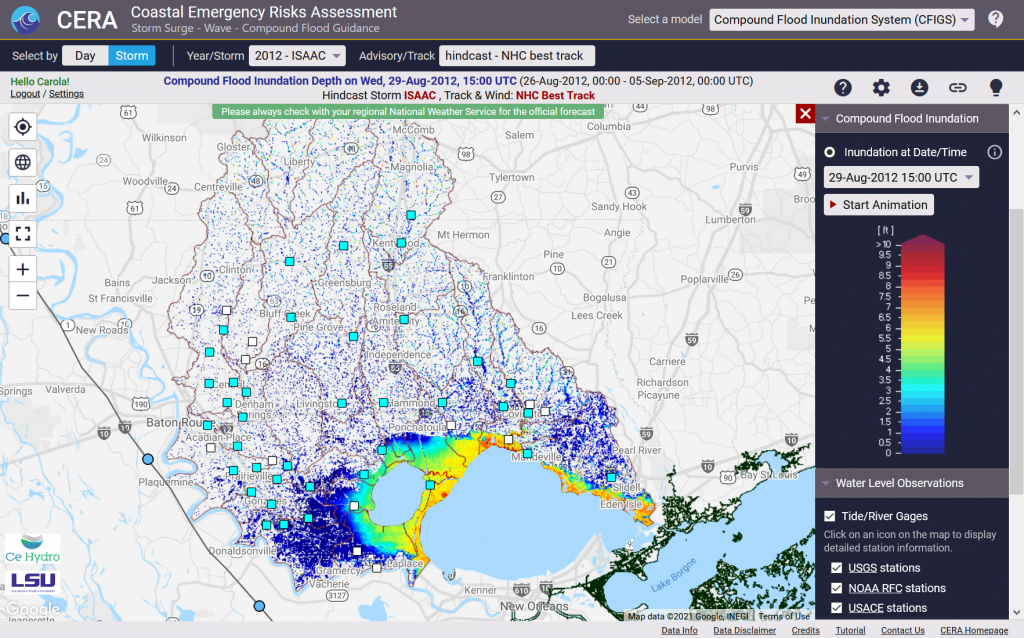
Additionally, compound flooding guidance will become operational to CPRA for the upcoming 2021 hurricane season through the Compound Flood Inundation Guidance System (CFIGS) developed by CE Hydro. The CFIGS model will capture combined influences of storm surge and precipitation for watersheds in Louisiana that are of particular interest to CPRA for emergency response tasks. The CFIGS model results will be presented on the CERA interface through inundation animations (depth of water above ground) and hydrographs for water level comparison to model prediction (50 stations from USGS, USACE, and NWS).
One lesson learned from the 2020 hurricane season was that it is difficult to identify the areas of highest risk based solely on inundation mapping. CFIGS will therefore also introduce a new flood hazard layer to quickly identify areas during an event with a high risk of structural flooding.
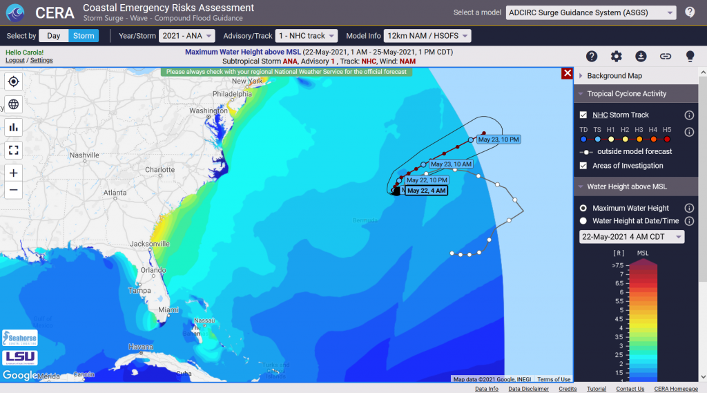
On May 22, the National Hurricane Center started issuing advisories for subtropical storm Ana that had formed near Bermuda – the first storm of the 2021 Atlantic hurricane season which officially starts on June 1.
The Coastal Emergency Risks Assessment (CERA) Group at Louisiana State University provides storm surge and flood inundation guidance through its interactive visualization portal all season. Please check our CERA storm surge tool at cera.coastalrisk.live for updates and get connected with our partners through Seahorse Coastal Consulting at LinkedIn.
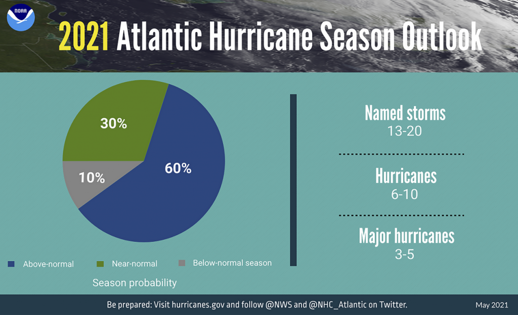
On May 20, NOAA issued it’s 2021 hurricane seasonal outlooks for the Atlantic and East Pacific basins. For the Atlantic, an active season is predicted.
According to NOAA, several climate factors that favor increased activity are reflected in this outlook, including: – the ongoing high-activity era that is in place since 1995 – ENSO Neutral or LaNina (will not suppress hurricane activity) – warmer-than-average sea-surface temperatures – reduced vertical wind shear – weaker Atlantic tropical trade winds – an enhanced African monsoon.
“Forecasters predict a 60% chance of an above-normal season, a 30% chance of a near-normal season, and a 10% chance of a below-normal season. However, experts do not anticipate the historic level of storm activity seen in 2020.”
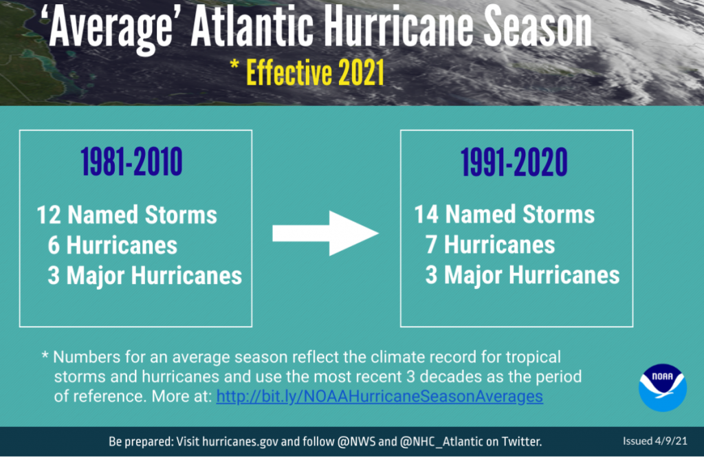
According to a statement released by NOAA on April, 9 2021, the Atlantic hurricane season averages have changed.
“Beginning with this year’s hurricane season outlooks, NOAA’s Climate Prediction Center (CPC) will use 1991-2020 as the new 30-year period of record. The updated averages for the Atlantic hurricane season have increased with 14 named storms and 7 hurricanes. The average for major hurricanes (Category 3, 4 or 5) remains unchanged at 3. The previous Atlantic storm averages, based on the period from 1981 to 2010, were 12 named storms, 6 hurricanes, and 3 major hurricanes.”
The CERA Group at Louisiana State University is pleased to announce a release of the CERA storm surge and flood visualization tool for the 2021 hurricane season.
NEW: Download capability for time series at specific location as requested by user feedback
NEW: Open time series chart through search by coordinates
If you would like to learn more about these features, please visit this blog entry.
The CERA release also includes the following new features for all models:
Vector graphics for a polished look
Google Maps background map in black and white, putting emphasis on storm surge information visibility
The following new CERA features are for specific storm surge/flood models:
ADCIRC Surge Guidance System (ASGS):
Update of USGS, USACE, NOAA water level stations to reflect latest agency adjustments
Download of inundation GeoTiffs for storms as requested by user feedback
Gage stations show water levels of the previous storm advisory for comparison with the current storm advisory as requested by user feedback
Extratropical Storm Surge and Tide Operational Forecast System (ESTOFS):
CERA visualizes NOAA’s new ESTOFS-Global mesh including water height and wind; additional features will follow
Compound Flood Inundation Guidance System (CFIGS):
CFIGS combines influences of precipitation and storm surge/tidal fluctuations developed by CE Hydro, LLC. Results are generated for selected watersheds in Louisiana
CFIGS will go operational for the 2021 hurricane season and displayed on the CERA website


 Gage stations for the