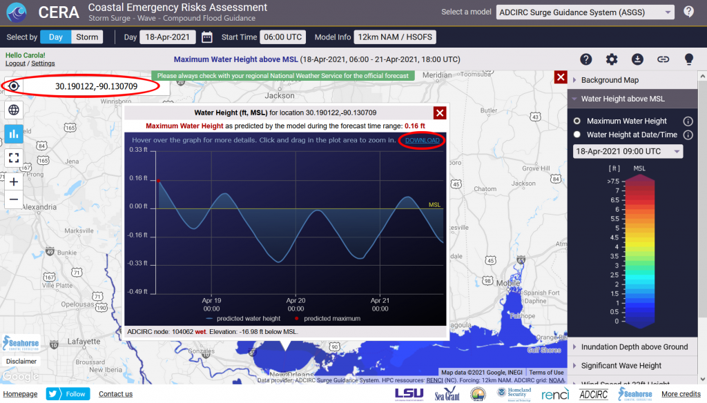
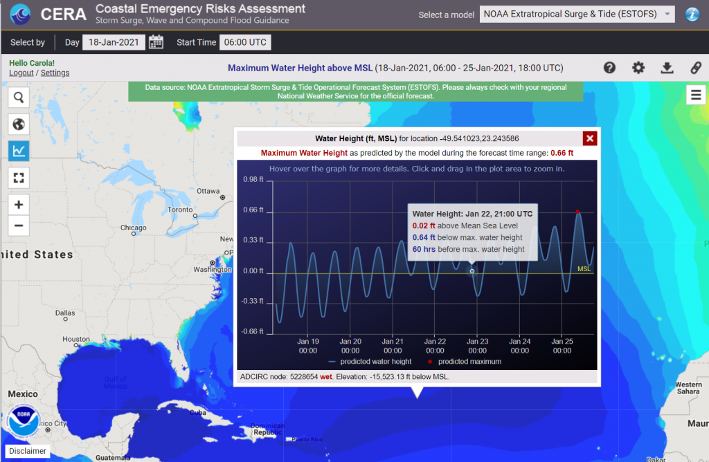
ESTOFS-Global maximum wind levels now online

We have been working with the NOAA Coast Survey Group to retrieve the ESTOFS-Global maximum wind levels from their cloud service and are happy to announce that the GFS forced wind maps are now available on the CERA web mapping tool.

You can view it here.

By default, opening CERA (https://cera.coastalrisk.live) displays the ESTOFS maximum water height layer. If you wish to view the wind layer, please select the wind speed tab in the map legend.

ESTOFS-Global wind layer on CERA. Data: courtesy of NOAA Coast Survey Group

CERA goes global using NOAA ESTOFS

https://cera.coastalrisk.live/

The CERA team is happy to announce a major upgrade using the Global Extratropical Surge & Tide Operational Forecast System (ESTOFS-Global) developed by NOAA’s Office of Coast Survey. High-resolution water level forecast guidance is now provided for the entire globe.

ESTOFS-Global as viewed on CERA

CERA provides the maximum water level height for the 06Z UTC cycle once a day. Using the CERA ‘time series’ feature displays maximum water levels at any point of interest on the map.

Unregistered users will now see the ESTOFS-Global map by default. Registered users can switch between ESTOFS-Global and customized maps from ADCIRC Surge Guidance System (ASGS) at any time using the ‘Select a model’ box at the top of the site.

You can also use the “Map Settings” option dialog at the upper right of the website to change your model preference upon opening CERA.

A time series on ESTOFS-Global on CERA

 With this update, CERA transcends its national capability to an international level in extratropical flood forecasting using NOAA’s data.

New GeoTIFF download functionality

The CERA Group is excited to announce a first release for selected hindcasts that will allow you to download the maximum inundation with a 50 meter resolution from the CERA website.

The following hindcasts are now available for download as GeoTIFF:

2020: Zeta, Delta, Sally, Laura, Isaias, Hanna
2019: Dorian, Barry
2018: Michael, Gordon, Florence
2017: Irma, Harvey
2016: Matthew

To download these GeoTIFFs, please select the maximum inundation layer from the legend for the desired storm, then select the download button in the top right (“Download GeoTIFF”). CERA has the capability to create GeoTIFFs on demand. We will provide this functionality for storm runs in the 2021 hurricane season.